Unconformities
Unconformities are gaps in the geologic record that may indicate episodes of crustal deformation, erosion, and sea level variations. They are a feature of stratified rocks, and are therefore usually found in sediments (but may also occur in stratified volcanics). They are surfaces between two rock bodies that constitute a substantial break (hiatus) in the geologic record (sometimes people say inaccurately that "time" is missing). Unconformities represent times when deposition stopped, an interval of erosion removed some of the previously deposited rock, and finally deposition was resumed.
Commonly three types of unconformities are distinguished by geologists:
|
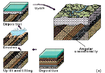
Angular Unconformities are those where an older package of sediments has been tilted, truncated by erosion, and than a younger package of sediments was deposited on this erosion surface. The sequence of events is summarized in the pictures at left. First: subsidence and sediment deposition occurs; Second: rocks are uplifted and tilted (deformation); Third: erosion removes the uplifted mountain range; Fourth: subsidence occurs, the sea covers the land surface, and new sediments deposition occurs on top the previous land surface. Then the cycle may repeat. |
|
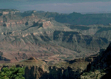
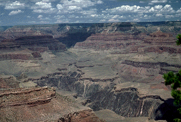
For geologists, one of the most famous angular unconformity is the Grand Unconformity in the Grand Canyon of Arizona. Here tilted sedimentary rocks of Precambrian age (lower half of photo) are overlain by younger sedimentary rocks of Phanerozoic age (Cambrian and younger, upper half of photo). The two packages of strata are clearly separated by an angular unconformity that is best seen just left of the center of the photo. |
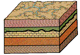 |
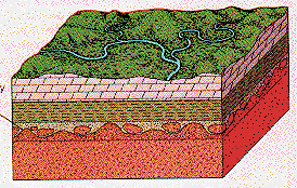
Disconformities are also an erosion surface between two packages of sediment, but the lower package of sediments was not tilted prior to deposition of the upper sediment package. The sequence of events is as follows: First: subsidence and sediment deposition; Second: uplift and erosion; Third: renewed subsidence and deposition. Because the beds below and above the disconformity are parallel, disconformities are more difficult to recognize in the sedimentary record. In the diagram at left, the disconformity is indicated by an irregular black line between the 3rd and 4th rock unit from the bottom. |
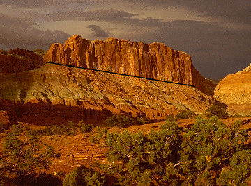 |
This picture shows a disconformity in Capitol Reef National Park, Utah. The Chinle Formation (Triassic), the slope forming unit in the central portion of the picture, has a very sharp contact (black line) with the overlying Wingate Sandstone (uppermost Triassic, forms steep cliff). This contact is considered a disconformity. |
 |
Nonconformities are unconformities that separate igneous or metamorphic rocks from overlying sedimentary rocks. They usually indicate that a long period of erosion occurred prior to deposition of the sediments (several km of erosion necessary). In the diagram at left, the igneous/metamorphic rocks below the nonconformity are colored in red. |
 A nonconformity at the base of the Grand Canyon succession. The dark rocks in the bottom of the gorge are Archean Vishnu schist, and are overlain by younger Proterozoic and Phanerozoic sediments. |
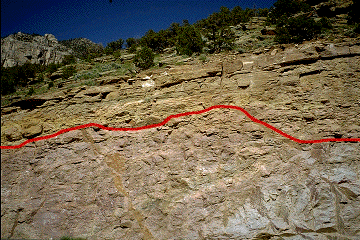 A nonconformity in the Wind River gorge of Wyoming. The red line points out the irregular contact between Precambrian granitic rocks and Phanerozoic sediments. |
UNCONFORMITIES ARE THE RECORD OF MAJOR EPISODES OF UPLIFT, EROSION AND SUBSIDENCE DURING THE GROWTH OF THE CONTINENTS AS EARTH HISTORY PROGRESSED. THEY ARE THEREFORE IMPORTANT EVIDENCE FOR CRUSTAL MOBILITY THROUGHOUT EARTH HISTORY.